‘photography’ Category
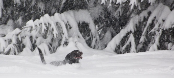
Snowpocalypse
We didn’t panic, but we did lose power for two days (and went through pretty severe gadget and internet withdrawal, probably more-so than heat withdrawal). Between the news, facebook, twitter, and everything else, the big storm (32.4 inches of snow here in around 36 hours) has been well covered, so instead of going on about it, I’m just going to post some photos from the big event (and a couple from the December snowstorm).


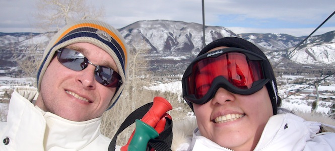
Aspen Skiing
Kathie and I just returned from a great vacation: Skiing in Aspen, Colorado! Dan graciously invited us and some other friends to stay at his family’s condo, which was in a great location, convenient to everything in Aspen.
Kathie’s blog has our day-by-day journal, so I’m not going to repeat everything here… just click through and check out the story there! We’ve also uploaded our vacation photos to an Aspen Vacation album in our Gallery.
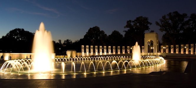
Washington Photo Safari
A week and a half ago I went on a “Washington Photo Safari” — a very early (and very original!) birthday gift from Kathie. The safaris are short (3-hour) practical photography classes in and around Washington DC, usually focusing on a particular aspect of photography. My class was “Monuments at night”. Scott came along as well, and the evening started off great with 1) an impossibly good parking spot 50 feet from Constitution Ave, and 2) nearly perfect weather, considering the time of year.
There were six to eight people in our class, and we started by hearing all about tripod use and shutter speeds. We started at the World War II memorial, where the lighted fountains were a great night subject. We also had the Washington Monument to the East and the Lincoln Memorial to the West to photograph. Next was the Korean War Memorial, 19 haunting statues of soldiers dramatically lit from below, and then we went inside the Lincoln Memorial. The last two stops were the Vietnam Memorial, and the Albert Einstein Memorial.
I had a few technical difficulties through the night (dirt on lens, crooked tripod, problems focusing clearly at night), but still took some pretty nice photos I think. The best of the night are in my gallery here, and a sample is below:
Hawai’i Trip, Part 5
We knew Tuesday was going to be a really long day. We were headed to the volcano which is on the far side of the island. Saddle Road cuts right between the two big mountains on the island, but our car rental agreement only allows 4x4s on the road — not our little Chevy Cobalt — so we had to take the long southerly route. We were told it would take us about 3 hrs to get to the volcano park, then another 1½ hrs to get to the lava viewing site (outside the park and on the coast at Kalapana).
Since we were still getting up relatively early, we headed to Lava Java to get our daily dose of cinnamon pastry goodness and headed south for our drive. This morning did not start out quite as hazy as normal in Kona. Since the volcano constantly spews out lava into the ocean, huge plumes of sulfur dioxide steam are released into the air. The trade winds carry the gray fog west to Kona all day long, and it has been officially named vog (volcanic fog). The residents in Kona hate it when Kīleaua is active because the vog can get pretty bad and cast a thick haze over the west coast. Apparently it’s been quite bad for the past few months.
Our drive to the volcano was uneventful with very few other cars on the road. We definitely seem to have hit off-season in Hawaii — in general most of the places we’ve been were very quiet (which we think is just fine). We made it to the Volcano Park by about 11am and headed straight to the Visitors center where we could get the most up-to-date information about the volcano. We confirmed that active lava flow is currently not visible at the park but the best time to watch was in the evening along the coast, so we had plenty time to see the park before the lava viewing. A relatively new vent at Halema’uma’u Crater contains a liquid lava lake, but the lake is only visible from directly overhead (i.e. helicopter). The vent is constantly spewing out poisonous sulfur dioxide gas, so half of Crater Rim Drive which circles the volcano was closed where the gas crosses the road.

Poisonous sulfur dioxide venting from the caldera closed much of the road that loops around Kīleaua’s rim.
We drove down the open part of the road to the steam vents and the first overlook. Steam vents are found throughout the park but at the first overlook you can see it most prominently. Mostly these are areas where rain falls, gets heated by the warm volcano rocks and comes back out as steam. It’s definitely hot, and a little fragrant. At the overlook we were able to see the huge gas vent at Halema’uma’u Crater with an even better view at Jaggar Museum. No wonder the Kona residents get annoyed: that thing puts out major amounts of vog!

A better view of the Halema’uma’u Crater.
We also hiked through the 400-year old Thurston Lava Tube. Lava tubes are tunnels formed when the top part of the lava exposed to the air cools and hardens, while liquid lava continues flowing underneath. Eventually the volcano stops pumping out lava, and the liquid drains away leaving a smooth, hollow tube. The Thurston tube is giant, about 20 feet in diameter at the largest point. We followed the dimly-lighted path 450 feet to a stairway up and out, but since Kat had done her homework before vacation, we brought flashlights and were able to skip the exit and continue another 150 feet through the unlighted tunnel. It’s amazing that once you get past the first curve in the tunnel, it immediately becomes pitch black. It was a bit spooky going so far in the dark, and we only saw one other couple make the trek into the back of the tunnel.

At the entrance to the Thurston Lava Tube
Next on the agenda was a drive down Chain of Craters road, which is a 20-ish mile drive from the 4,000 foot top of the volcano, down to the coast. The road passes along many old, and some recent lava flows, and many very old (and large) craters from past eruptions. At one point we came across two Nēnē, endangered Hawaiian geese. Along the coast, the road is blocked off, so we parked and walked another half-mile to the point where the roadway was covered by a 2003 eruption.

Chain of Craters road ends where the lava flows of 2003 covered it
After driving back up to the caldera, we stopped at the overlook for Kīleaua Iki crater. There is a great hike to this crater, but we just didn’t have the time for it this trip. The hike is a few miles through the rainforest, and then across the smooth surface of a mile-wide hardened lava lake inside the crater. Instead, we looked down onto the crater lake surface from the rim of the crater 400-feet up.

Kīleaua Iki crater, and 50 years ago, a lake of lava
By now it was afternoon, and we were quite hungry, so we stopped in Volcano Village, a small town near the summit of Kīleaua, and had some lunch. We continued driving east, so that we could get to the lava viewing area by evening. We drove down to the coast, and along the other end of Chain of Craters road. Twice we came to fairly long sections of road that were covered by lava flows in March, 2008, and we had to drive up and on top of the lava for a while until the road was accessible again. The state and county had paved a rough lane on top of the lava so our car didn’t have too hard a time, but it was still pretty odd. At one point we saw a “For Sale” sign stuck in the lava pointing to a house that somehow had been spared when the lava covered this side of the island and destroyed the community of Kalapana in 1990. There’s no power, water, or roads left so we don’t expect the house to sell very soon.
Eventually we made it to the end of the road, parked, and grabbed our gear (flashlights, camera, water, etc.). We followed a ½-mile hike across recent lava flows to get to the viewing area. The route was clearly marked, but it was interesting seeing and walking on the recent lava.

Our trek across the recent lava fields, to get to the viewing area
The viewing area was a roped-off area on top of the lava, right along the coast, and there was a pretty good crowd of people gathering. The lava from Kīleaua has been flowing continuously since 1983, but the eruptions and flows change location, type, and intensity all the time. A couple years ago, visitors could walk right up to the flowing lava, when it was at the other end of Chain of Craters road. Earlier this year, it was visible coming down the mountainside in ribbons. During our visit, the top of the flows had cooled and hardened, so the lava was flowing through tubes and wasn’t visible. However, once the lava reaches the ocean, it pours in creating huge plumes of steam (and creating new land). As the waves crash on the shore, they block the lava flow for a second, causing huge explosions of lava to shoot up in the air every 15 seconds or so. The best time for viewing is dusk, when the orange glow of the lava is most easily visible. We think we were about ¼ to ½ mile away. It was amazing to watch, but difficult to photograph for a variety of reasons, such as the plume of steam obscuring the lava, the distance requiring a long zoom lens, the night viewing requiring high ISO and long exposures, and my lack of a sturdy tripod. I took about 100 pictures, and am pretty happy with some of them, despite them being fairly grainy (shot at ISO 3200) and shaky (most were taken with 2-second exposures at 200mm zoom). Below are a couple good examples:


Well after nightfall we decided we’d better start heading back, so we made the trek back across the lava (in the dark this time, except for our flashlights) to our cars, and then began the long, 3+ hour drive back across the island to Kailua-Kona.
Hawai’i Trip, Part 4
Monday morning we were able to sleep until 6am which was a nice improvement. At this rate, we’ll be used to Hawaiian time right before we have to head back home! We wanted to keep it relatively easy since Tuesday would be our big volcano day. We grabbed some yummy pastries from Lava Java and headed south.

Mike at Pu’uhonua o Hōnaunau (Place of Refuge) National Historical Park
Our drive took us through Kona coffee farm country, a swath of land 2 miles wide and 20 miles long. After some zig-zags through the mountains and a drive back down to the coast, we arrived at Pu’uhonua o Hōnaunau (Place of Refuge) National Historical Park. This was where royal chiefs lived but it was also a place of refuge for defeated warriors, woman and children during times of war, and those who broke the royal laws and needed absolution. The royal grounds were separated from the place of refuge (pu’uhonua) by a massive stone wall. When we entered the park, we were given a brochure that provided information and a map for a self-guided tour. We saw recreations of temples (thatched huts), canoes, wood carvings of gods, and other indications of traditional Hawaiian life. There is also a canoe landing area that is now used by the endangered Hawaiian Green Turtles (honu) to sun themselves during the day. While we were there, there was one turtle already relaxing on the beach and we were also able to watch another turtle swim up.

A Hawaiian green turtle basking in the sun
Partway back up the road from the coast we stopped at St. Benedict’s Painted Church, the walls and ceilings of which are painted to show numerous biblical scenes. Back on the main highway we stopped at a macadamia nut farm where we experimented with some old farm equipment to process nuts. Kathie particularly enjoyed snacking on the fresh nuts right out of their shells.
Next we stopped at Bay View coffee farm, and the gentleman manning the gift shop took us on a thorough tour of the farm. Since this coffee farm is a bit off the beaten path, it was quiet and we were the only ones there. Coffee trees are pretty small overall, they almost appear to be a cross between a tree and a bush. Cherries (the fruit of the tree) are picked when they turn bright red. The cherries are then taken to the coffee mill where the green beans are separated from the cherry (imagine the seed inside a cherry, that would be the coffee bean). The cherry pulp is used as fertilizer, and the beans are soaked in water for 24 hours to remove the protective clear coating around the beans. Then the beans are dried — either in a dryer or laid out and dried by the sun. Next, the husks on the beans are removed and re-used as mulch, and the beans are sorted by size — the larger the bean, the more flavor, so the big beans are extra fancy, and smaller are fancy, then prime. Most cherries contain two coffee beans, but sometimes there is only one bean and it’s round. These are called peaberry and are used for milder coffee. The green beans can be stored in burlap bags for 2 years before roasting, so while they only harvest cherries 6 months out of the year, they can roast and sell beans all year long. The difference between medium and dark roast is only one minute of roasting time — medium roast is 16 minutes while dark roast is 17 minutes. The tour was very interesting and for a coffee-lover like Kathie, very intriguing to see how the entire process works.
Having sampled the Kona coast the whole morning, we opted to have lunch and spend the afternoon exploring the northwest Kohala coast, looking for a nice beach to relax at, get some sun, go for a swim, and read our books. Lunch at Huggo’s On The Rocks was really disappointing. The fantastic location and views (the tables and chairs are in the sand 15 feet from the beach) unfortunately couldn’t make up for the food.
The Kohala coast is famous for its beaches, and is where most of the expensive resorts have been built up recently. The resorts look incongruous in this setting, since the northwest quadrant of the island is a stark moonscape of lava beds devoid of almost any life. Then occasionally along the highway is a fancy resort entrance, complete with beautiful palm trees and perfectly manicured grass. Turning in to the resort, the grass and trees end abruptly after a hundred feet, and the drive through black rock continues to the resort at the beach. Interestingly, Hawaiians have their own form of graffiti, where they arrange dead pieces of coral (which is bright white) into words and patterns on top of the jet-black lava landscape along the highways (see photo below). This continues for 50 miles along the western coast, and also elsewhere on the island. The grafitti is continuously changing as people re-arrange the coral daily to personalize their own messages.

Much of the Big Island is a barren landscape of ancient lava flows.
Our beach hunting didn’t go as well as planned, since the day before, Big Island Civil Defense spotted approximately 15 large (6- to 16-foot) tiger sharks along the Kawaihae coast beaches. After a few unsuccessful attempts at finding an open beach, we came to Spencer Beach Park which was open, mostly empty, and a great place to spread out in the sun (or shade from trees along the beach) and read in front of the shark warning sign. Several hours later, having both finished our books, we packed up just before sunset and headed back down the coast.

Darn.
Before returning to our condo, we stopped in Kailua as usual for a light bite to eat. We had a fairly light pizza / salad dinner at Boston Basil’s, followed by some ice cream and a giant snowcone for Kathie from Scandinavian Shave Ice which froze her insides until we could get her wrapped up in a sweatshirt.

Evening in Kailua-Kona